
Finding your way
Ottawa 3 Speed #4: Wayfinding & signage, interprovincial crossings, Scott Street and more!

Good evening and welcome to the fourth week of Ottawa 3 Speed! I’m trying something new out here by sending this out in the evening, instead of the morning. If you have a preference of when you get this, let me know! If you’re reading this online instead of in your inbox, here’s your opportunity to subscribe now!
This week we’re going to dive into wayfinding & signage with some ideas on how to City could sign some routes better (or at all). Then we have a good project update, a bad project update, and the last update on Joel LePole before he’s yanked out of the road forever.
First Gear: To help cyclists get around the city, Ottawa needs to add better wayfinding signage to its bike infrastructure
A couple months ago, the City of Ottawa completed work on the Rideau River Western Pathway by finally closing up a gap in the middle section of the path. Aside from two on-road sections at the western end and in the middle (along Cameron Avenue and between Windsor Park and Brantwood Park), you can now ride a bike on a fully separated multi-use path (MUP) in the 7 km along the Rideau River between Strathcona Park and Linda Thom Park.

The recently-completed section of the Rideau River Western Pathway, with generic “bike route” signs on the on-street section and no signage on the off-street section (City’s map)
But you wouldn’t know that just by looking at it. There are no signs calling this path the “Rideau River Western Pathway”, and there are no signs telling you where it leads. And aside from generic “Bike Route” signs on the on-road sections, there are no signs even telling you that you’re on one. This is a missed opportunity to provide something that should be the default: wayfinding signage that names the route and shows you how it connects to others. New streets don’t open without street signs, and new highways don’t open without names.
This missed opportunity isn’t unique: new cycling infrastructure in Ottawa is frequently added without any signage. Two other recent examples of large and inconspicuous projects are the new multi-use paths along the Confederation Line LRT and Hospital Link Road (I will name these the Confederation MUP and the Hospital Link MUP, since the City didn’t name them).
The Confederation MUP is effectively a bicycle highway between Laurier Avenue and Hurdman Station. But if you’re getting on it at Laurier, you’d have no idea that it goes that far or that it connects to other important routes and destinations (Crosstown Route 3, uOttawa Station, Lees Station, Rideau River Eastern and Western Pathways, VIA Rail, the baseball stadium, etc.) The Hospital Link MUP has the same problem. This brand new cycling route connects the Rideau River Eastern Pathway with the unnamed MUP along Lynda Lane Park (which itself is the connection to Conroy Avenue and Greenboro beyond), but there are no signs along this new path to tell you that.
Despite these examples of wayfinding failures, the City has actually demonstrated that it can do wayfinding well. The Nepean Trail, completed last year, has a terrific wayfinding signage package to help cyclists navigate the sometimes tricky connections of on and off-road facilities between Fisher Heights and Tanglewood. Greenboro also has welcoming and informative wayfinding, with a large maps of local network at gateways, time estimates between destinations, and directional signs at all decision points. These two signage programs are successes, and should be the template for all future projects.
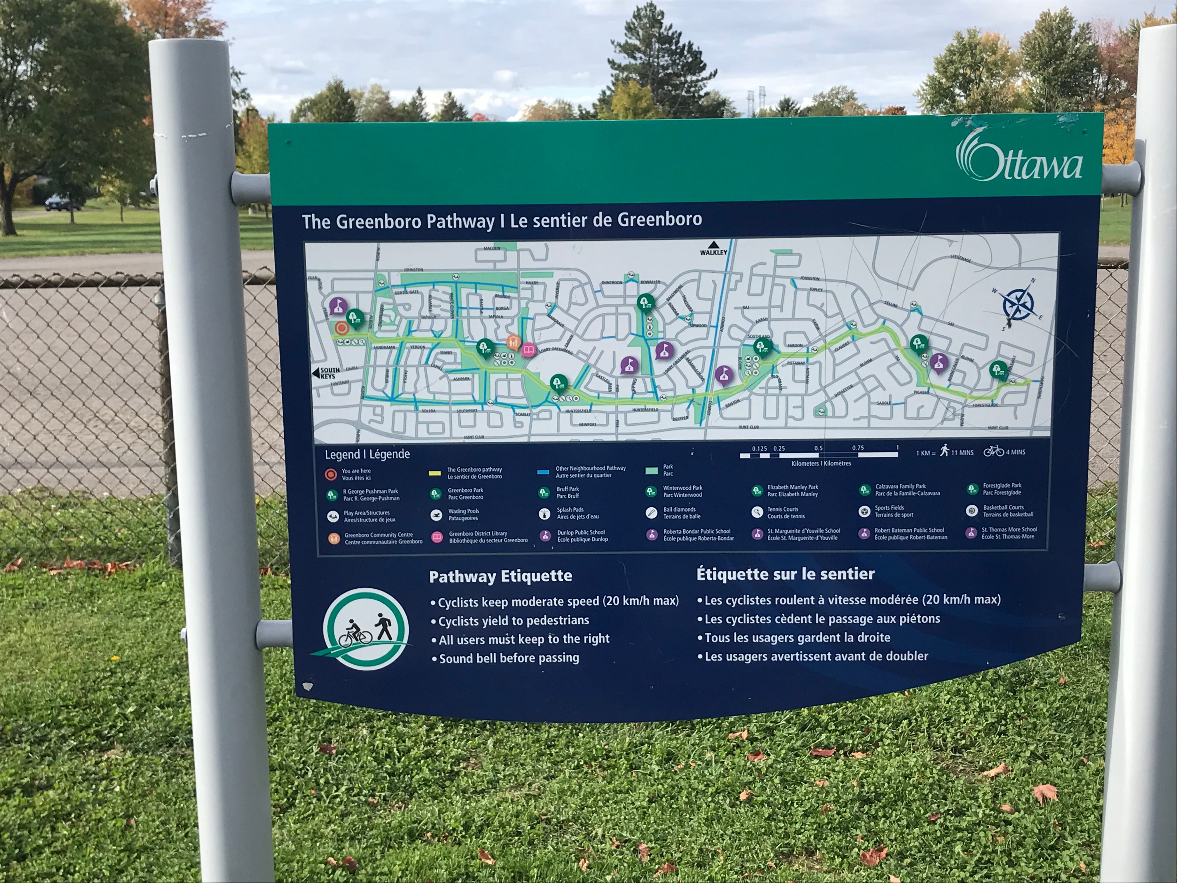
Gateway signage for the Greenboro Pathway. There are additional direction signs at every fork in the path, with travel time estimates to destinations
They have not been templates so far. The City has told me these were isolated projects, and that without an “official wayfinding strategy” it would be difficult to repeat them. But it's easy to imagine how much improved the Confederation MUP, Hospital Link MUP, and Rideau River Western Pathway would’ve been with signage like this. Wondering if it would be just as easy to imagine as actually design, I decided to try it for myself.
I created these sample wayfinding signs based on templates the City has previously used, specifically from the Nepean Trail template. These signs tell a cyclist where they are, where the path they’re on can take them, and how that path connects to other cycling infrastructure. I hope you’ll agree that signs like this would be a welcome addition to the currently nameless and signless routes they’re designed for. They weren’t too complicated to make, and it didn’t take very long either.

A sample of the concept signs I created for the RRWP MUP. View the rest of the signs, for this route and for the Confederation and Hospital Link MUPs, here.
There is no good reason why wayfinding signs weren’t part of these three projects to begin with, and there’s no good reason why wayfinding signs aren’t a part of other recent or upcoming projects. The City of Ottawa has demonstrated that it can do this task well—so they should do it at every opportunity.
While an official wayfinding strategy may be a part of the new Active Transportation Plan (now delayed to 2022), a simpler solution can come much quicker. All the City needs to do is include wayfinding and signage on all new paths and routes going forward, just like they would for streets.
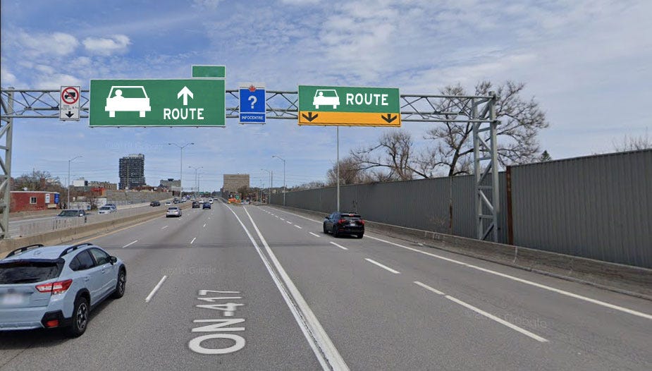
If we signed car routes like bike routes
Second gear: Around the city
Public consultation
The NCC has an online questionnaire to help guide its development for interprovincial crossings of the Ottawa River in the National Capital Region. The questions are pretty high-level visioning-type stuff, and there’s not much at the moment to add or dispute (“The system of crossings will support equitable mobility and the safe and efficient movement of people and goods, while respecting the region’s natural environment and cultural heritage.” Sure, sounds good!) Obviously it’s important to emphasize active and sustainable transportation in current and new crossings, but the NCC already knows that. Still, you can take the survey until October 27, and be sure to follow along as this study develops.
City of Ottawa’s Transportation Master Plan survey, with additional mapping activity for pedestrian and cycling missing links, is still available until October 23.
Sherwood Drive traffic calming study survey is open until November 16. Help turn those underused parking lanes into bike lanes!
Project updates:
Scott Street: Bad update from the first newsletter, unfortunately. The formerly bidirectional section of the Scott Street multi-use path that was changed into a unidirectional (despite being surrounded by bidirectional connections), is not going to change back into bidirectional. That means if you’re biking east on the Scott MUP, you’ll have to dismount and walk a block before getting back on your bike. This obviously makes no sense, but City Staff are holding firm on it. There will eventually be an eastbound option on the other side of the road when Scott is rebuilt (eventually), and more details of those plans are expected later this year.
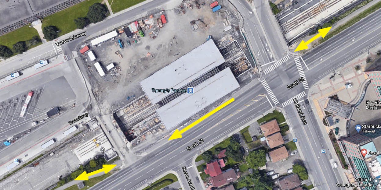
The Scott Street MUP: bidirectional east and west of Tunney’s Pasture Station, unidirectional in front of the station. Dismount and walk if you’re eastbound.
Elgin Street: Good update here. @jonathanmcleod tweets that the new “jug handle” cycletrack has begun construction. This will provide cyclists a safer alternative than the current floating bike lane (before you get thrown into a dangerous intersection, which needs to get rebuilt as a protected intersection).
Third gear: What’s new on #ottbike
It was a beautiful day on Saturday, October 17 (my birthday!) and as @nadrobi points out, the pathways were absolutely packed with cyclists. Many people on twitter had mentioned crammed paths, and I overheard people on those crammed paths talking about how crammed they were. While there may yet be the “lesser demand” the NCC referred to in explaining its decision to end their open parkways pilot project, it certainly didn’t happen this past weekend. There are calls for a pilot extension, and calls for a winter version of it to encourage winter cycling. Hopefully the NCC is listening.
There’s a phantom bike lane on Aylmer Avenue. Signage placed along the road earlier this year points to a bike lane, but no bike lane was ever painted. Capital Ward is investigating. There’s another phantom bike lane on Sebring Avenue by Hampton Park. Know of any others?
Elgin Street has officially been open! @carbonfixated reminds us all that the initial public feedback called for cycling facilities, and the initial concepts included a bike lane option.
@mbonsma tweets about the difficulty of biking from Vanier to the Ottawa river path. It’s only a 15 minute ride in a logical route, but filled with unexpected hazards. If you bike enough that you start to get numb to the poor biking conditions around you, refresh your perspective with Madeleine’s excellent thread here.
Joel LePole
Last week I wished Joel LePole an enjoyable retirement, thinking the saga was over. Well, I was wrong! Joel got an additional boost of popularity after an appearance on CBC News Ottawa. The good news is that spotlighting this issue may make the City more careful with their projects and more open with their communications in the future (the plans for this area weren’t released to the public, and so everybody was in the dark about what was going on). Unfortunately, this coverage may have also furthered some misconceptions.
Joel, a pole located directly in the middle of a new cycletrack on Booth, represents all the times when the City of Ottawa planning staff overlooked small but consequential details when constructing new cycling infrastructure. There are too many of these examples to count, from the forgotten bike lanes on Booth to the last-second bait-and-switch of the bike lane on Lyon. It’s very important that cycling advocates keep a close eye on the planning and construction process so they can catch potential City flubs before they become costly and dangerous mistakes, and so the impulse with bringing attention to Joel LePole was a good one.
However, Joel LePole is not in itself an example of an error that needed to be caught. A representative for Zibi, who are looking after this section, explained that the pole pre-existed the work on the cycletrack and has to stay in place until December, when Hydro Ottawa connects new utilities. They were they paved the area around the pole first, rather than wait until next year, potentially speeding up completion of the new facility. Should we have to wait months of a pole in the middle of the cycletrack? No, ideally the construction sequencing is more seamless. Could the pole be more conspicuous in the meantime? Yes. But also remember this cycletrack is not open or completed—it’s still an area in construction.
Joel LePole has a wonderful personality that captured the attention of people and brought a spotlight to a too-common issue of costly, stupid mistakes by the City that put cyclist’s lives in danger. That’s good. But Joel itself was not a mistake that needed correcting, and so it’s unfortunate that this was an example that became popular. When the City screws up next—and they absolutely will—we should make whatever pole, hole, cliff, boulder, or curb put in the wrong place much more famous.
And now I wish Joel a happy retirement for good! Looking forward to his extraction. Maybe we can get the construction schedule from Zibi and Hydro Ottawa and have a nice, distanced celebration together when they finally say goodbye to Joel.
Events
It’s time again for the Bike Ottawa Annual General Meeting! This year is different, since the AGM—like so many other things this year—is going online. I’d highly recommend both attending the Bike Ottawa AGM and becoming a member of Bike Ottawa. I’m glad to have attended my first AGM three years ago, and now this year am ending my term as a member of the Board of Directors. Bike Ottawa does a lot of great work, and when you become an active member you can be a part of the organization accomplishing even more.
RSVP for the 2020 Bike Ottawa AGM here.
Thanks for reading this week’s instalment of Ottawa 3 Speed! Next week we’re going to talk about Winter Cycling, since it seems to be on a lot of people’s minds! I’ve been riding all four seasons in Ottawa and Toronto for the last seven years and am excited to share my enthusiasm for riding in the winter, along with some tips and tricks.
Once again, if you enjoyed these weekly updates I encourage you to subscribe and/or share with others who might enjoy it. See you next week.