

Glebe Avenue reconstruction plan misses opportunity to improve cycling route
Glebe Avenue reconstruction plan misses opportunity to improve cycling route
The City's process limitations and deference to 1950s policies prevent the extension of a two-way cycling facility

In 2024, the City of Ottawa will be rebuilding the section of Glebe Avenue between Bank Street and O’Connor Street. They have to dig up the road to replace the pipes underneath, and after that happens they’ll have to put the whole thing back together. These types of reconstruction projects are rare opportunities to implement new designs for streets that improve how they work.
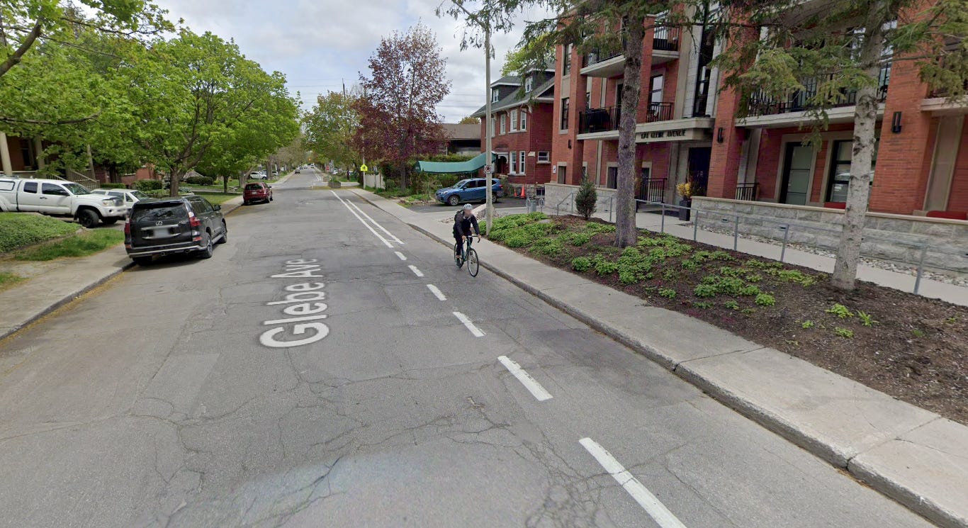
Unfortunately, the City’s new design for Glebe Avenue keeps it mostly the same: it will remain a one-way street, with one travel lane for eastbound vehicles, one bike lane for eastbound cyclists, one sidewalk for pedestrians, and one lane of parking. While new traffic-calming elements will make Glebe Avenue safer, its utility will be unchanged.
Is there a design that could have made Glebe Avenue work better? If so, why didn’t the City choose it?
To answer those questions, let’s start by putting you in charge. Imagine you are hired by the City to create a new design for Glebe Avenue. Except let’s expand our scope—instead of just the one block of Glebe Avenue east of Bank Street, we’ll also include the remaining three blocks west of Bank Street since they are scheduled for resurfacing soon. The project, then, is to redesign the full 1.4-kilometre, four-block street from scratch. You’d start this project by looking at policy and context.
The context: Glebe Avenue is a residential street in the heart of an urban neighbourhood that bisects a traditional main street commercial area (Bank Street). Along with homes, Glebe Avenue is dotted with three schools, and is close to other schools along with a community centre. Glebe Avenue also serves as a connector beyond the neighbourhood via public transit: it’s the most direct route to the closest LRT station at Dow’s Lake and is a bus route for the #56 eastbound (this section of the route only operates during peak periods Monday to Friday).
In terms of city policy, Glebe Avenue is designated as a local road, meaning it should facilitate direct access to destinations, discourage high-speed through-traffic for drivers, and minimize trip lengths for pedestrians and cyclists.1 The street is especially important for cyclists because it has traffic lights at both Bank Street and Bronson Street (cyclists seek out signalized crossings of busy arterials like bridges over water), and connects straight through to Carling Avenue. Glebe Avenue is the only east-west street in the Glebe whose full length is designated as a cycling spine route (spine routes are meant to handle large cycling volumes and connect to the greater network).2 But aside from site-specific policy, the overarching city philosophy—especially for local residential streets like this—is to prioritize people-oriented mobility and public transit over private motor-vehicle transportation.3

With that in mind, your opening steps would be to create safe and convenient pedestrian and cycling facilities. That means sidewalks on both sides of the street and an allowance for riding a bike in both directions. There are three ways you can make a street two-way for cyclists: cyclists can travel in general traffic lanes both ways on a two-way street, cyclists can travel in separated facilities in both ways (regardless of whether the street is one-way or two-way), or a bit of both (separated one way, mixed-traffic in the other). The City’s policy on determining whether separated cycling facilities are needed is based on a calculation of traffic speeds and volume.4 In this case, the low speeds and volumes of a local street like Glebe Avenue suggest separated facilities are not needed. However, because it’s a cycling spine route, a bus route, and a school route, City staff prefer separated facilities here.
But every design has constraints, and the main constraint for Glebe Avenue is road width. The current curb-to-curb width is about 9.5 meters, not including sidewalks, and there’s some wiggle room for expansion on each side. Still, by providing two sidewalks and two-way protected cycling facilities, you don’t have enough room for both two-way bus-route vehicle travel and on-street parking. On-street parking is desirable for a local street—since it emphasizes a local destination and slows traffic down—so you pick that over having two travel lanes.
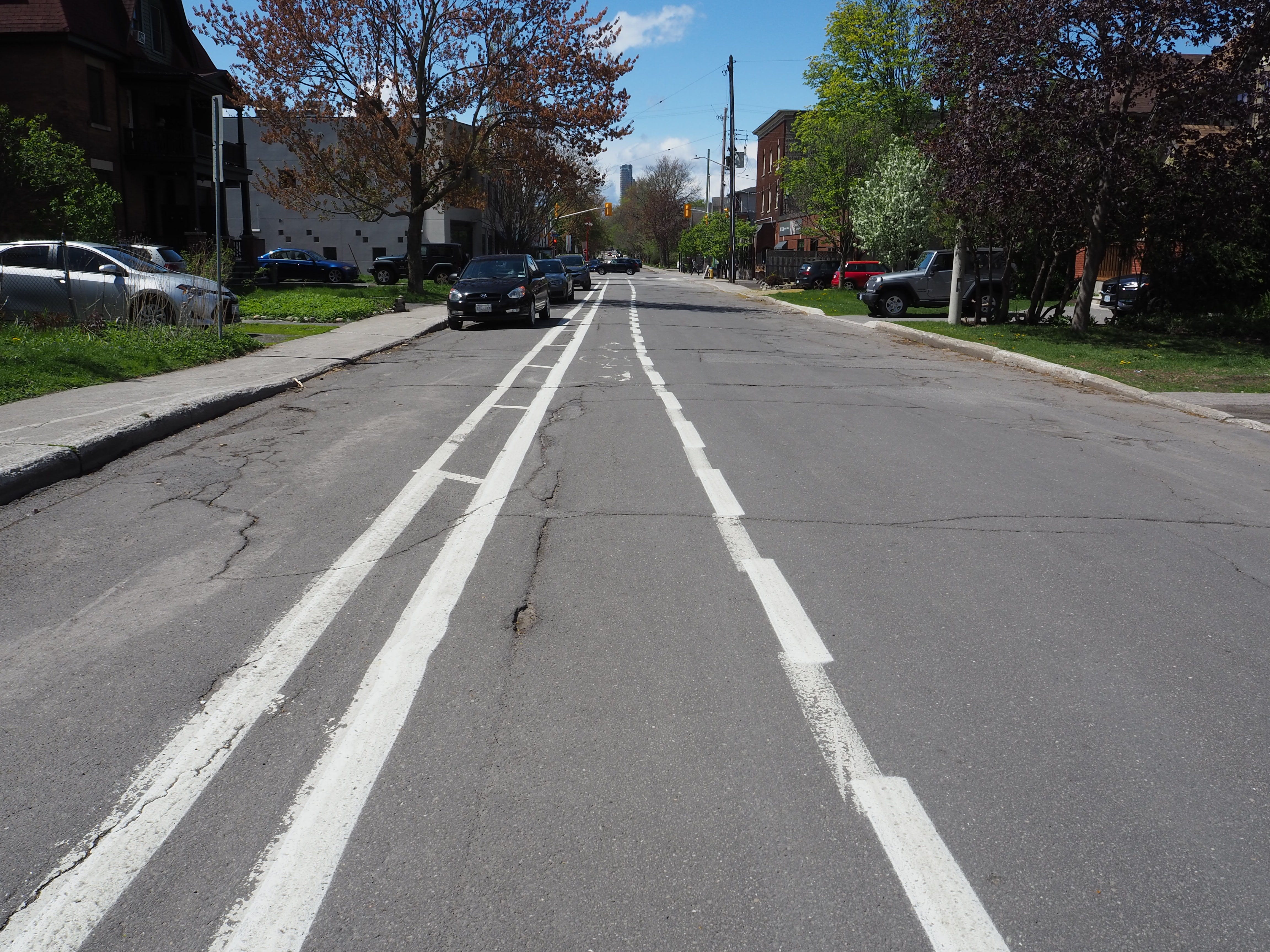
What you’re left with is a design that has one lane of vehicle travel, one lane of parking, a two-way cycling facility, and a sidewalk on both sides of the street. As it happens, this is the exact design of one existing block of Glebe Avenue, between Percy Street and Bronson. This is not, however, what the City has planned for the new redesign of the block between Bank and O’Connor. The main difference between these sections is the function for cyclists: on one block of Glebe Avenue, both eastbound and westbound cycling is allowed; on the other three blocks, eastbound cycling is allowed—but westbound cycling is prohibited.
Allowing two-way cycling on one-way streets (called “contraflow cycling”) brings many advantages for all road users. According to a 2023 study of 508 one-way streets using 22 years of data, adding a contraflow lane is cheaper to build than other cycling infrastructure, increases cyclist enjoyment (by letting them use quieter roads), reduces travel distance between two points, simplifies travel planning (they can use the same route both ways), increases connectivity to other bike routes, increases the overall amount of cycling, reduces sidewalk-riding (which causes conflict with pedestrians), and may even reduce crash risks compared to exclusively one-way facilities.5 These advantages are known and widespread: contraflow cycling on narrow one-way streets is the norm for European cities with high cycling rates.6 The City of Ottawa is also aware of these advantages. That’s why they’ve created contraflow lanes on one-way sections of many local residential streets, including Cameron Avenue, Gladstone Avenue, O’Connor Street, Garland Street, Graham Avenue, McLeod Street, and Stewart Street. If you don’t see the benefit of contraflow cycling, imagine you were only allowed to walk one way on the sidewalk of a one-way street.
Prohibiting two-way travel for cyclists makes streets more dangerous for all road users, makes cycling less convenient, and results in fewer people riding bikes. It also criminalizes cyclists who want to travel the most direct route, which cyclists are known to do. These effects are all against city transportation policy. Two-way cycling, then, should be the default function of all one-way streets—and the onus should be on the City, if presenting a one-way only design, to prove why prohibiting two-way cycling would better meet transportation goals.
So I asked the city why their new design for Glebe Avenue only allows cycling in one direction, and how doing so would make the street safer and more convenient to use than a two-way cycling design.
The first answer they provided was that there is not enough room on Glebe Avenue for two-way cycling. This isn’t factually true, as demonstrated by the fact that one section of Glebe Avenue—with the same width as the others—already fits a two-way bikeway, a lane of parking, and a travel lane.


The second answer suggested that cyclists wishing to travel westbound on Glebe Avenue could instead use First Avenue, a one-way westbound street a block south. Glebe and First are “paired” one-way streets that together provide two-way travel, staff told me, and it would be redundant to provide westbound travel for cyclists on both of them. But First Avenue and Glebe Avenue are not equal: First Avenue lacks the signalized connections on Glebe Avenue, meaning a cyclist would have to ride past their destination and then double back rather than travelling in a straight line. This explanation is also inconsistent with past city decisions. Most existing contraflow facilities operate on one-way pairs because most one-way streets operate as pairs. The fact that McLeod Street is a one-way westbound paired with Flora Street as a one-way eastbound, for example, didn’t stop the city from allowing two-way bicycle travel on McLeod in 2020.
The City’s odd justifications for their selected design suggests there’s something else guiding it beyond policy and best practices. And there is: the redesign of Glebe Avenue isn’t about what should be done when given a blank slate, but what can be done given the limitations of process and precedent.
First, process. A main obstacle in making a better Glebe Avenue is how the City chooses the scope of their projects. In this case, the four blocks of Glebe Avenue are split up into two separate projects. The section east of Bank is being torn up and replaced in 2024; the two sections west of Lyon will be stripped and repaved in “2-3 years.” (The section in between won’t be touched at all, apparently.) Because these projects are happening separately at separate times, the easiest way to keep the street consistent is to rebuild it in the same configuration as before. If these projects were coordinated together, then a holistic redesign solution could have been achieved. Instead, splitting them apart with a narrow scope continues the status quo.
Changing the status quo is by nature disruptive, but it can be especially challenging in established neighbourhoods like the Glebe. It’s simply easier to keep things the way they are, which means keeping Glebe Avenue one-way and prohibiting westbound cycling. But the status quo has to have started somewhere, and only by knowing why something is the way it is can you can determine if those reasons are still relevant. So, why is Glebe Avenue one way in the first place?
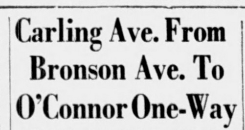
Well, Glebe Avenue was actually a two-way street until 1943. At that time, it was still called Carling Avenue—and functioned the same way as the rest of Carling Avenue, a cross-town arterial through route. But the section east of Bronson that eventually became Glebe Avenue was different because it was residential, with homes on each side. The residents of these homes were growing more upset as their street got busier and busier with traffic, both due to the increasing popularity of the automobile and the introduction of buses by the Ottawa Electric Railway Company. These buses were apparently so loud and heavy on Glebe (Carling) Avenue that, according to a city councillor, “people with false teeth had to move.”7 In August 1943, a group of residents petitioned City Hall to restrict traffic to one way on Glebe (Carling) Avenue between O’Connor and Bronson, theoretically halving the amount of vehicle and bus traffic.8 They were successful—and quickly: the by-law was signed just a month later. The street has been one-way for the past 80 years.
But the immediate effect of the abrupt switch was cascading traffic issues on adjacent streets—and residents started pushing for the City to fix their streets too.9 In the 1950s, the City responded by proposing to convert every east-west street in the Glebe into alternating one-ways.10 The main advantages to this approach, according to transportation staff at the time, was that one-way streets would increase vehicle capacity, speeds, and efficiency.11 Despite these supposed benefits, only one more pair was converted (Pretoria Avenue and Isabella Street).
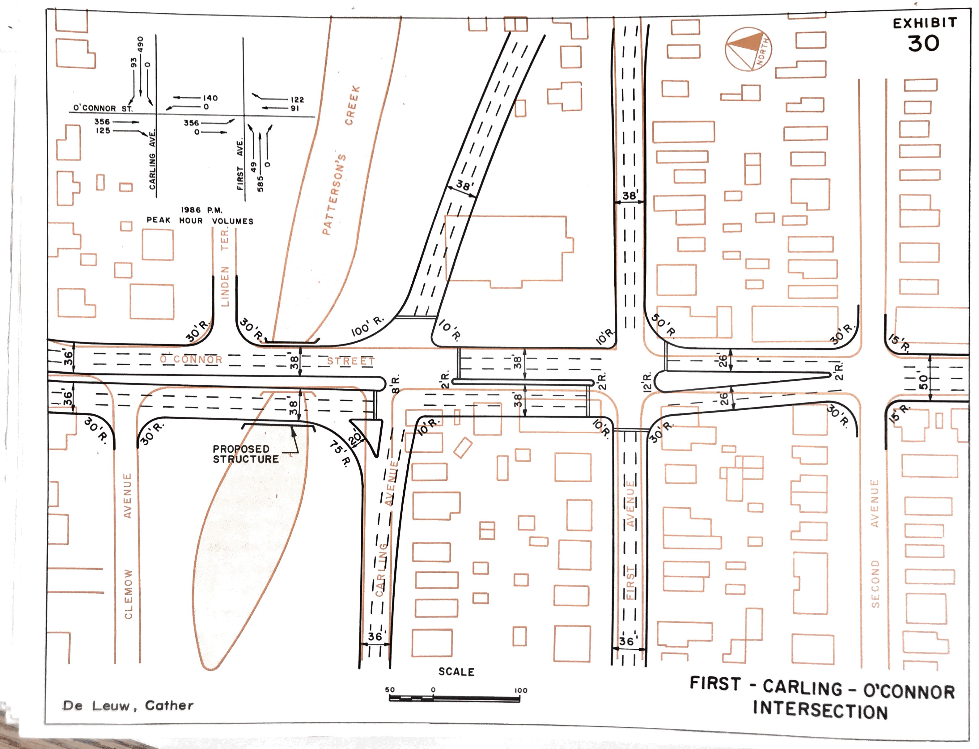
In the 1960s, traffic engineers had an even better idea to accelerate traffic flow through the Glebe: they would connect Carling Avenue with Industrial Avenue by expanding the paired First Avenue and Glebe Avenue into a six-lane crosstown arterial and extending them over two new bridges.12 Residents and the community association pushed back and proposed an alternative created by a local architect, John Leaning.13 His concept involved directing arterial traffic around the Glebe instead of through it and would have transformed residential streets into two-way cul-de-sacs—including Glebe Avenue, which would have been closed at Bronson.14 This plan was watered down through negotiations into the Glebe Traffic Plan and implemented starting as a pilot project in 1973.15 It retained traffic-calming measures but removed most of the proposed closures and directional switches. It was at this time that the section of Carling Avenue east of Bronson was renamed Glebe Avenue to “[symbolize] residents' hopes that Carling east of Bronson will become a quiet residential street—not at all like the busy commercial artery that is Carling west of Bronson.”16 Glebe Avenue has been stable in the five decades since, and it’s fair to say that the dream of it becoming a quiet residential street has been realized.

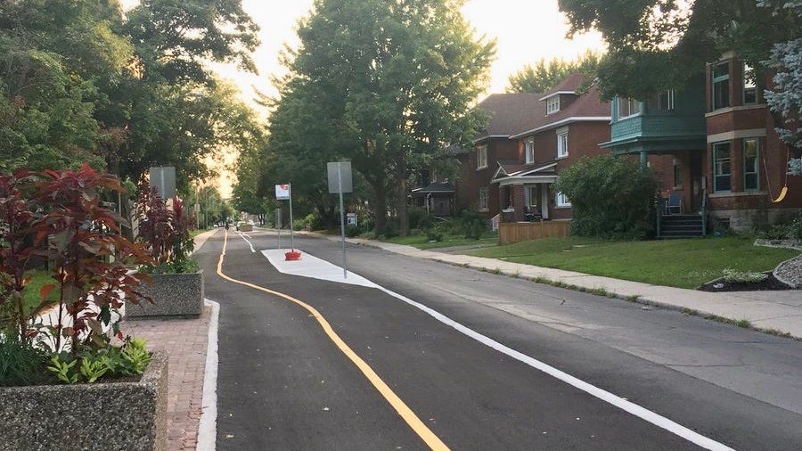
In 2004, the newly amalgamated City of Ottawa updated the Glebe Traffic Plan, making tweaks to signage elements like speed limits, stop signs, and turning/parking restrictions along with small infrastructure changes like speed humps, bulb-outs, and raised intersections. Once again, the goal was to reduce traffic speeds and volumes. The Glebe Neighbourhood Cycling Plan from 2014 led to the one-way painted bike lane on Glebe Avenue east of Percy Street and a two-way bikeway on one block west of Percy.
In short: Glebe Avenue became a one-way street because a handful of residents nearly a century ago wanted fewer cars and buses on the road, and mid-century traffic engineers obsessed with vehicle flow kept it that way. Those reasons can no longer justify converting a two-way street into a one-way. The context and our priorities have changed. Glebe Avenue is now a quiet local residential street, and the city’s policy for local residential streets is to prioritize pedestrians and cyclists over vehicle capacity and efficiency. The only remaining reason for keeping Glebe Avenue one-way is its narrow width—but that reason isn’t relevant to bicycles, which are smaller than cars.
If Glebe Avenue was being built today, it wouldn’t be built the same way as it was in 1943. But the street is being built today—rebuilt—and despite this, the next iteration of the street will look much like it did before. Allowing two-way cycling would have improved the function of this street, but the permanence of the planned new infrastructure will prevent that function for another generation.
The chance to redesign a street from scratch is rare—and it should be capitalized on to fix past mistakes, adhere to present best practices, and meet future targets. Instead, project planning restrictions and an unquestioning view of current conditions has led the City to maintain a configuration of a street that goes against their own policies. If you’re ever on your bike wondering why there’s a missing link between you and your destination, this is how it happens.
Public consultation for the Glebe Avenue Integrated Renewal will take place later this spring.
References
Transportation Master Plan, 2013. City of Ottawa. p. 68.
Ottawa Cycling Plan, 2013. City of Ottawa. p. 53–54.
Transportation Master Plan, 2013. City of Ottawa. p. 4.
Ottawa Cycling Plan, 2013. City of Ottawa. p. 43.
Caroline Tait, Roger Beecham, Robin Lovelace, Stuart Barber. “Contraflows and cycling safety: Evidence from 22 years of data involving 508 one-way streets,” Accident Analysis & Prevention, Volume 179, 2023. p 1.
“Briefing: Contraflow Cycling,” European Transport Safety Council. March 2018. p. 2.
“Consider Street Railway Service to Ottawa South” The Evening Citizen, July 20, 1937. p. 5
“Carling Ave. From Bronson Ave. To O’Connor One-Way” The Evening Citizen, Aug 11 1943. p. 12
“Will Resist Plan Of Running Buses Along Second Ave.” The Evening Citizen, September 15 1943. p. 1
“Ask One-Way Streets For Glebe Area” The Evening Citizen, January 19, 1952. p. 21.
Traffic and Transportation Plan for Ottawa, Canada. Wilbur Smith & Associates. 1955. p. 45–49.
Report on the Replacement of the Pretoria Avenue Canal Crossing, De Leuw, Cather & Co. of Canada. 1968.
Leaning Plan for An Improved Roadway Environment in the Glebe [Brief], Glebe Community Association, 1972
A Proposal for Roadway Environment in An Existing Community, National Capital Commission, John Leaning. 1970.
“Traffic-slowing plan affects many streets in Glebe” The Ottawa Citizen, July 19, 1973. p. 3
“Street name change asked” The Ottawa Citizen, July 17, 1973. p. 4.